Developer Joe Taylor gives local restaurant maps to the City of West Columbia
Looking for fine-dining in West Columbia? Do you want something fun and casual, or maybe you’ve heard locals talk about a great spot but don’t know where it is located. Pick up a copy …
This item is available in full to subscribers.
Subscribe to continue reading. Already a subscriber? Sign in
Get 50% of all subscriptions for a limited time. Subscribe today.
Please log in to continue |
Developer Joe Taylor gives local restaurant maps to the City of West Columbia
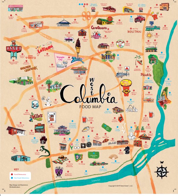

Looking for fine-dining in West Columbia? Do you want something fun and casual, or maybe you’ve heard locals talk about a great spot but don’t know where it is located. Pick up a copy of the new West Columbia Food Map for answers to your culinary dilemma.
The map is the creation of developer Joe Taylor, one of West Columbia’s leading cheerleaders. “It was just something fun to do,” said Taylor, who made the map a gift to the city.
The 18-by-24 inch full-color folded map shows 57 locally owned West Columbia restaurants and eateries as well as a number of non-food attractions, all chosen by Taylor, who wrote the accompanying legend on the reverse side, from No 1 Al’s Upstairs to No. 57 Zesto. “This is a way to support the many mom and pop small businesses who are the backbone of the community. The strength of these locally owned restaurants shows what can happen when you have a business friendly local government,” Taylor said.
Taylor, the former S.C. Secretary of Commerce, had 5,000 copies of the map printed.
They are available at the West Columbia City Hall and other locations around the city and can also be obtained at Taylor’s office on State Street or by sending a self-addressed stamped envelope to WC Food Map, 146 State St., West Columbia, SC 29169.
“Joe Taylor has provided the city, its great restaurants and all of our visitors with a really cool way to see all the great dining options we have in West Columbia. The map
makes you want to go out and eat,” said West Columba Mayor Tem Miles. “Once again, Joe Taylor has helped to tell the story of why the ‘West Side is the Best Side,’” Miles said, referring to the city’s location on the west bank of the Congaree River.
Artwork for the map and its design was created by Mike Daikubara, an industrial designer, author and urban sketcher from Charlotte. Sketches include longtime West Columbia favorites like Café Strudel, Al’s Upstairs, Terra and Compton’s Kitchen; newcomers such as Black Rooster and the WECO Bottle & Biergarten; and iconic landmarks such as the Gervais Street Bridge, Brookland Baptist Church and Riverbanks Zoo. A sketch of Zesto and its iconic ice cream cone graces the map’s cover.
Daikubara posts many of his sketches to Instagram at #mikedaikubara “Joe had an idea about the project and he picked out all the locations,” Daikubara said. “I was not familiar with the locations. I just moved to North Carolina about a year ago, and South Carolina is still very new to me. He told me about all these great restaurants and I went to check them out. I drove to each one and either took a picture of it, or I drew it on location. Joe got me to get a taste of many of the places too. Just delicious!"


Comments
No comments on this item Please log in to comment by clicking here