Laura turns into Category 4 hurricane
Tracking shows it may yet swing our way
Hurricane Laura quickly strengthened to a Category 4 storm on Wednesday.
It was expcted to make landfall near the Texas-Louisiana Gulf Coast last night.
The National Hurricane Center (NHC) …
This item is available in full to subscribers.
Subscribe to continue reading. Already a subscriber? Sign in
Get 50% of all subscriptions for a limited time. Subscribe today.
Please log in to continue |
Laura turns into Category 4 hurricane
Tracking shows it may yet swing our way
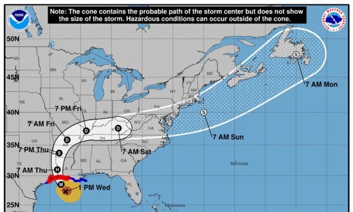
Hurricane Laura quickly strengthened to a Category 4 storm on Wednesday.
It was expcted to make landfall near the Texas-Louisiana Gulf Coast last night.
The National Hurricane Center (NHC) warned that Laura will bring “unsurvivable storm surge.”
It will cause “large and destructive waves” from “Sea Rim State Park, Texas, to Intracoastal City, Louisauraiana.
“This surge could penetrate up to 30 miles inland from the immediate coastline,” according to the NHC.
Laura's trjectory is expected to take an eastern swing toward Lexington County.
Travel over land will diminish its power, but we may expeact heavy rains this weekend.
Laura has maximum sustained wind speeds of 140 mph.
The eye of the storm is forecast to move over northwestern Louisiana on Thursday, and Arkansas Thursday night.
It will head to the Mississippi Valley Friday.
“It looks like it’s in full beast mode,” University of Miami hurricane researcher Brian McNoldy told The Associated Press.
“Which is not what you want to see if you’re in its way.”
Keywords
hurricane, Laura, Carolinas, sc, NC


Comments
No comments on this item Please log in to comment by clicking here